The Sky is a Forecast
Every cloud tells a story. High, thin clouds signal what’s coming in 12-24 hours. Low, dark clouds tell you what’s happening right now. Learn to read the layers and you’ll never be caught off guard again.

Three Altitude Layers
High clouds (above 20,000 ft): Cirrus, cirrostratus, cirrocumulus. Made of ice crystals. These are your early warning system. They show what’s arriving in 12-24 hours.
Mid clouds (6,500-20,000 ft): Altocumulus, altostratus. A thickening mid-level layer means a weather system is getting closer. You have 6-12 hours.
Low clouds (below 6,500 ft): Cumulus, stratus, nimbostratus, cumulonimbus. These are the now-casting clouds. Small white puffs mean fair weather. Dark towering columns mean get to shelter.
02 // KNOW YOUR CLOUDS
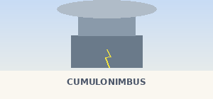
Cloud ID Guide


The Invisible Engine
Air pressure is the driving force behind all weather. You can’t see it directly, but you can read its effects in the clouds, wind, and temperature around you.

Reading Pressure Without Instruments
No barometer? No problem. Falling pressure shows up as: clouds lowering and thickening, increasing wind, smoke curling downward instead of rising straight, and sounds traveling farther than normal (you’ll hear distant engines or rivers more clearly).
Rising pressure shows up as: clouds breaking apart and lifting, decreasing wind, improving visibility, and morning dew or frost (clear skies allow heat to radiate away overnight).
What the Wind Tells You

Steady west/northwest wind: Generally stable conditions in North America. This is your “good weather” wind in most of the western US.
Wind shifting to south or east: Weather is changing. Warm, moist air is being pulled in ahead of a front. Expect clouds and eventually rain.
Rapidly increasing wind: A pressure gradient is tightening. The bigger the pressure difference between two areas, the harder the wind blows. Fast-increasing wind = fast-approaching system.
Sudden calm after wind: This is the most dangerous signal. A dead calm before a storm often means you’re in the path of the worst of it. Take shelter.
Countdown to a Storm
Storms don’t appear out of nowhere. They follow a predictable sequence of cloud types that gives you hours of advance warning if you know what to look for.
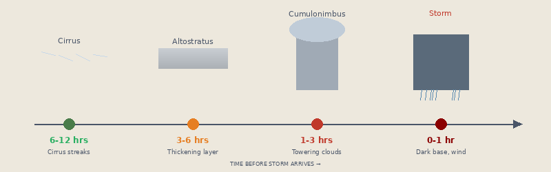
12-24 hours out: Cirrus clouds appear and start spreading. The sky still looks mostly clear, but those wispy streaks are the front’s calling card.
6-12 hours out: The sky develops a milky haze (cirrostratus), then a gray sheet (altostratus). The sun becomes dimmer. A halo may appear around the sun or moon.
1-6 hours out: Clouds lower and darken. Cumulus clouds grow vertically into towers. Wind picks up and may shift direction. Temperature may change noticeably.
0-1 hour: Cloud base drops rapidly. Dark, ominous wall of cloud approaches. Strong wind gusts. This is your last chance to reach shelter or safe terrain.
Old School Weather Signs
These aren’t old wives’ tales. Each one is backed by real atmospheric science.
Red Sky at Night
A red sunset means dust particles are scattering light in dry western air. Since weather moves west to east, that dry air is heading your way. Expect a clear tomorrow.
Red Sky at Morning
The dry air has already passed you to the east. Moisture is coming from the west. The old sailor’s warning holds true: “Red sky in morning, sailor take warning.”
Halo Around Sun or Moon
Caused by ice crystals in cirrostratus clouds. These high clouds are the leading edge of a warm front. Rain typically arrives within 12-24 hours.
Heavy Morning Dew or Frost
Forms under clear, calm skies when heat radiates away overnight. Clear skies at night = clear skies in the morning. A good sign for the riding day ahead.
Sudden Temperature Drop
A fast 10-15°F drop means a cold front is passing. Expect strong, gusty winds, possible thunderstorms along the front line, then clearing skies behind it.
Sound Carries Farther
When you hear distant sounds (trains, rivers, highways) louder than normal, it means air is denser and wetter than usual. Falling pressure. Rain is coming.
Can You Read the Sky?

You spot these thin, wispy streaks at high altitude on a clear morning. What should you expect?
A) Nothing, they’re decorative B) Rain within 12-24 hours C) Immediate thunderstorm D) Strong ground winds
REVEAL ANSWER
✓ B) Rain within 12-24 hours. Cirrus clouds are the advance scouts of an approaching warm front. If they thicken over several hours, rain is almost certain.

This cloud type towers from low altitude to high, with a flat anvil-shaped top. What is it?
A) Stratus B) Cumulus C) Cumulonimbus D) Altocumulus
REVEAL ANSWER
✓ C) Cumulonimbus. The thunderstorm cloud. It produces lightning, heavy rain, hail, and dangerous winds. If you see one building, get off exposed terrain and away from tall isolated objects.

You see this sky in the evening. What does it mean for tomorrow?
A) Storm tomorrow B) Fair weather tomorrow C) No useful information D) High winds tonight
REVEAL ANSWER
✓ B) Fair weather tomorrow. “Red sky at night, sailor’s delight.” The red color means dry, dusty air is to your west, and since weather moves west to east, that clear air is headed your way.

This repeating “fish scale” pattern in the sky is called a “mackerel sky.” What does it often precede?
A) Extended clear weather B) Rain within 6-12 hours C) Tornado conditions D) Temperature inversion
REVEAL ANSWER
✓ B) Rain within 6-12 hours. Altocumulus in a “mackerel sky” pattern indicates moisture at mid-levels. “Mackerel sky, rain is nigh.” It’s a reliable short-term rain predictor.

These bulging, pouch-shaped formations hang from the underside of a cloud. What do they indicate?
A) Fair weather ahead B) Severe turbulence and possible severe weather C) Morning fog clearing D) Snow is coming
REVEAL ANSWER
✓ B) Severe turbulence and possible severe weather. Mammatus clouds form in highly unstable air, often on the underside of a cumulonimbus anvil. They signal that severe weather is active nearby.

You see this smooth, lens-shaped cloud hovering near a mountain peak. What’s the primary danger it signals?
A) Volcanic activity B) Extreme high-altitude winds C) Imminent earthquake D) Temperature inversion
REVEAL ANSWER
✓ B) Extreme high-altitude winds. Lenticular clouds form when fast-moving air flows over a mountain. They indicate winds that can exceed 100 mph at altitude. Avoid ridgeline travel when you see these.
© Deviant Ink // Read the Sky Guide